April 21, 2026
Marine Spatial Planning (MSP) & Blue Economy
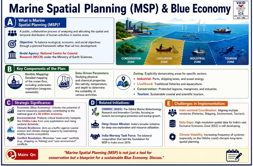
1. Definition & Context:
-
MSP: A public, collaborative process of analyzing and allocating the spatial and temporal distribution of human activities in marine areas.
-
Objective: To balance ecological, economic, and social objectives through a planned framework rather than ad-hoc development.
-
Nodal Agency: National Centre for Coastal Research (NCCR) under the Ministry of Earth Sciences.
2. Key Components of the Plan:
-
Benthic Mapping: Detailed mapping of the ocean floor, including underwater vegetation (seagrass, seaweeds).
-
Data-Driven Parameters: Studying physical and chemical properties like salinity, temperature, and depth to determine the suitability of various activities.
-
Zoning: Explicitly demarcating areas for specific sectors:
-
Industrial: Ports, shipping lanes, and ocean energy.
-
Livelihood: Traditional fisheries and aquaculture.
-
Conservation: Protected lagoons, mangroves, and estuaries.
-
Tourism: Sustainable coastal and scientific tourism.
-
3. Strategic Significance;
-
Economic (Blue Economy): Unlocks the potential of marine resources sustainably, contributing to the national goal of a $5 trillion economy.
-
Environmental: Protects critical biodiversity hotspots like Chilika Lake from over-exploitation and rising sectoral demands.
-
Climate Resilience: Acts as a buffer against coastal erosion and climate change impacts by maintaining healthy marine ecosystems.
-
Conflict Resolution: Minimizes “user-user” conflicts (e.g., shipping vs. fishing) and “user-environment” conflicts.
4. Related Initiatives:
-
OMBRIC (2025): The Odisha Marine Biotechnology Research and Innovation Corridor, focusing on biotech-led ecological protection and startup growth.
-
Deep Ocean Mission: India’s broader initiative for deep-sea exploration and resource utilization.
-
India-Norway Task Force: The bilateral cooperation that laid the foundation for MSP in India since 2019.
5. Challenges in Implementation;
-
Inter-sectoral Coordination: Aligning multiple ministries (Fisheries, Shipping, Environment, Tourism).
-
Data Gaps: High-resolution spatial data for India’s vast Exclusive Economic Zone (EEZ) is still developing.
-
Climate Volatility: Increasing frequency of cyclones (especially on the Odisha coast) disrupts long-term spatial planning.
Conclusion :
As the first state to adopt MSP in this phase, Odisha serves as a model for “Sustainable Coastal Governance.” For India to realize its maritime potential, MSP must be integrated with the Sagarmala Project and Coastal Regulation Zone (CRZ) norms to ensure that development does not come at the cost of ecological integrity.
About Sagarmala Project:
Launched in 2015, Sagarmala is the flagship program of the Ministry of Ports, Shipping, and Waterways to reduce logistics costs and leverage India’s 7,500 km coastline.
The 5 Pillars (Core Components):
-
Port Modernization & New Port Development: Upgrading existing ports (e.g., JNPA, Mundra) and building greenfield ports (e.g., Vadhavan Port in Maharashtra).
-
Port Connectivity Enhancement: Improving “last-mile” connectivity via the PM Gati Shakti framework, integrating road, rail, and the Dedicated Freight Corridors (DFC).
-
Port-Led Industrialization: Creating Coastal Economic Zones (CEZs) and industrial clusters near ports to reduce transport costs for EXIM (Export-Import) trade.
-
Coastal Community Development: Focused on the “Blue Economy”—fishing harbor upgrades, skill development, and coastal tourism.
-
Coastal Shipping & Inland Waterways: Shifting cargo from congested roads/rails to water (e.g., National Waterway-1 on the Ganga).
Current Status :
-
Scale: Over 845 projects (₹6.06 lakh crore) are active.
-
Achievements: 315 projects are completed. Major ports handled a record 915 million tonnes of cargo in FY 2025–26.
-
Sagarmala 2.0: Now focusing on Green Shipping, smart port digitalization, and a target of 5% global shipbuilding share by 2030.
-
Financing: The newly formed Sagarmala Finance Corporation (SFC) (formerly SDCL) is raising $1 billion to fuel maritime infrastructure.
About Coastal Regulation Zone (CRZ):
The CRZ norms are issued under the Environment (Protection) Act, 1986. They regulate human activity near the shoreline to protect fragile ecosystems.
Classification (Based on 2019/2024 Norms)
| Zone | Description | Key Regulations |
| CRZ-I | Ecologically Sensitive Areas (Mangroves, Corals, Turtle nesting sites). | No new construction allowed; highest protection. |
| CRZ-II | Developed Urban Areas (Mumbai, Chennai, etc.). | Construction allowed only on the landward side of existing roads. |
| CRZ-III | Rural Areas (Relatively undisturbed). | Divided into III-A (Densely populated; 50m No Development Zone) and III-B (Sparsely populated; 200m NDZ). |
| CRZ-IV | Water Areas (Low Tide Line to 12 nautical miles). | Regulates fishing, pipelines, and prevents untreated sewage discharge. |
October 17, 2025
October 16, 2025
October 6, 2025
September 24, 2025