August 12, 2026
Glaciers of Zanskar: What is Peak Water?
Why in News?:
A recent study examined several glaciers in the Zanskar Himalaya of Ladakh over a multi-decade period, finding that glaciers are moving more slowly than about three decades ago due to climate-driven thinning.
Glaciers of Zanskar: Climate Change and Glacier Slowdown
Why in News?:
-
A recent study examined twelve glaciers in the Zanskar Himalaya of Ladakh over 1992–2023.
-
It found that glaciers are moving more slowly than about three decades ago.
-
The study links this slowdown mainly with glacier thinning caused by climate change.
-
Published in the journal The Cryosphere.
Why are Zanskar Glaciers Important?:
-
Zanskar contains some of the largest and most extensive glaciers of the Himalayas.
-
They act as natural freshwater reservoirs.
-
Meltwater during warmer months supports rivers, streams, agriculture, ecosystems, local communities, and hydropower potential.
-
This is particularly important because Ladakh is a cold-arid region with limited precipitation.
-
Zanskar glaciers receive much of their winter snowfall from mid-latitude Westerly Disturbances.
Key Link:
Western Disturbances to winter snowfall, then glacier accumulation, followed by summer meltwater and Indus basin water supply.
Key Findings of the Study:
| Indicator | Finding |
| Study period | 1992–2023 |
| Glaciers studied | Twelve |
| Average slowdown | 2.4 m/year per decade |
| Surface thinning, 2000–05 | ~0.22 m/year |
| Surface thinning, 2015–20 | ~0.57 m/year |
| Main observation | Glacier thinning is associated with slower ice movement |
Important Trend:
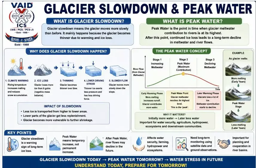
Glacier mass loss leads to thinning, reduced driving stress, and slower glacier flow.
How Does a Glacier Move?:
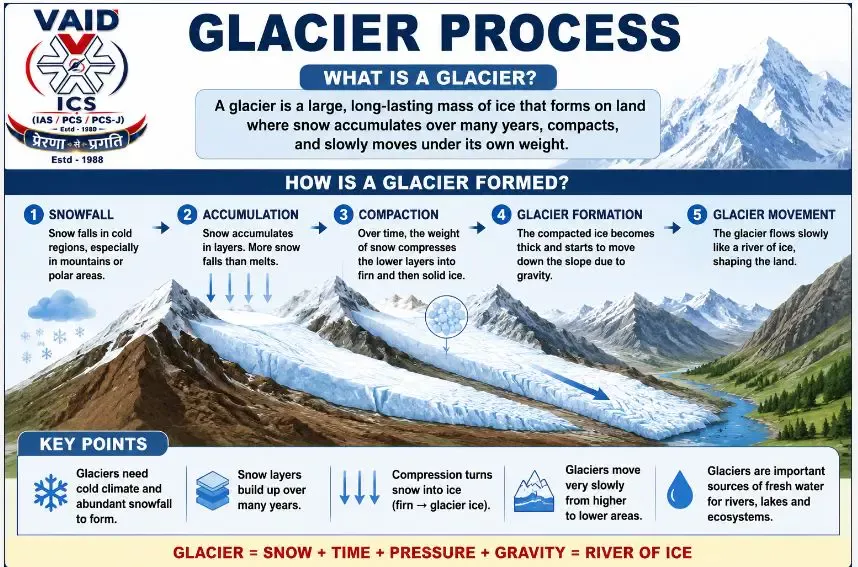
A glacier is not static. It is essentially a slow-moving river of ice.
-
Accumulation Zone: Area where snowfall and ice accumulation are greater, causing ice to gradually move downhill.
-
Ablation Zone: Area where melting and ice loss are dominant.
-
Terminus/Snout: Lowest end of the glacier.
Key Concept:
Glacier movement transfers ice from high-altitude accumulation areas to lower areas where melting is greater.
Why Does Glacier Thinning Slow Its Movement?:
When a glacier loses more ice than it gains:
-
Negative mass balance occurs.
-
Glacier becomes thinner.
-
Ice thickness and driving stress decrease.
-
Ice moves more slowly.
-
Less ice reaches lower elevations.
-
Lower parts receive less replenishment.
-
Further shrinkage may occur.
Exam-ready chain:
Climate warming leads to increased ice loss, glacier thinning, lower driving stress, reduced ice transport, and greater vulnerability to continued shrinkage.
This is an important physical mechanism connecting climate change with glacier dynamics.
Glacier Mass Balance:
Mass Balance = Accumulation – Ablation
-
Positive Mass Balance: Accumulation is greater than ablation, causing the glacier to gain mass.
-
Negative Mass Balance: Ablation is greater than accumulation, causing the glacier to lose mass and generally become thinner.
Major Components:
-
Accumulation: Snowfall, snow deposition, refreezing.
-
Ablation: Surface melting, ice melt, sublimation, calving in relevant glacier environments.
Glacier Slowdown and Variable Responses:
Not all glaciers respond identically to warming. Their behaviour depends on:
-
Glacier geometry
-
Slope
-
Ice thickness
-
Debris cover
-
Terminus/snout conditions
-
Subglacial hydrology
-
Basal sliding
-
Interaction with proglacial lakes
-
Local climatic conditions
Therefore, climate change produces a broad trend, but local glacier characteristics determine the exact response.
Important Exception: Glaciers Can Also Accelerate:
Glacier slowdown is not universal. Some glaciers may temporarily accelerate because of:
-
Increased meltwater reaching the glacier bed
-
Reduced friction due to basal lubrication
-
Glacier surges
-
Interaction with proglacial lakes
-
Marine processes in marine-terminating glaciers
Therefore, glacier velocity alone cannot be treated as a simple or universal indicator of climate change.
Impact on the Indus Basin:
The Zanskar glaciers are part of the broader Indus River system. Glacial melt is particularly important during dry summer months.
Short-term possibility: Peak Water
-
Initially: Glacier warming and thinning lead to increased melting and increased runoff, known as Peak Water.
-
Later: Continued ice loss leads to smaller glacier storage and reduced long-term meltwater contribution.
Thus, more melting today does not necessarily mean more water forever, creating a major long-term concern for water security, agriculture, hydropower, ecosystems, and downstream communities.
What is Peak Water?:
Peak Water refers to the point at which glacier meltwater contribution to a river reaches its maximum.
-
After this point: Continued glacier mass loss leaves less ice available for melting, leading to a declining meltwater contribution.
-
Significance: It creates a short-term increase followed by a long-term decline in glacier-derived water supply.
Why is the Indus Particularly Important?:
The Indus basin is highly dependent on water from snowfall, glacier melt, rainfall, and groundwater. Glacier melt is especially significant during summer, when precipitation may be limited in parts of the basin.
Therefore, glacier degradation can have transboundary implications because the Indus basin supports populations and economies across several countries.
Limitations of the Study:
The findings should not automatically be applied to every glacier in Ladakh.
Major limitations:
-
The study covered only twelve glaciers, whereas the Zanskar basin contains numerous glaciers.
-
Satellite-derived surface velocity cannot directly observe subglacial hydrology, basal sliding, or conditions beneath the ice.
-
Long-term ground observations remain limited for ice thickness, mass balance, bed conditions, ice temperature, and meltwater discharge.
-
High-altitude weather data are also limited.
Takeaway:
Remote sensing provides spatial and long-term monitoring, but field observations are essential for validation.
Why Long-Term Monitoring is Needed?:
Glaciers respond to climate change over decades, not merely years.
Requirements:
-
Satellite remote sensing
-
Glacier mass-balance measurements
-
Ice-thickness surveys
-
Ground-based observations
-
Ice-temperature monitoring
-
Meltwater-discharge measurements
-
High-altitude weather stations
-
Improved glacier-climate models
Best approach: Combining satellite data, ground observations, and climate models.
Global Significance:
Similar glacier slowdowns have been reported in:
-
European Alps
-
Alaska
-
Canadian Arctic
-
Andes
-
Parts of the Tibetan Plateau
Common mechanism: Glacier thinning leads to lower driving stress and slower ice flow, though local conditions can produce different responses.
Broader Environmental Significance:
Glaciers are important climate indicators. Changes in glacier area, thickness, mass balance, flow velocity, snow accumulation, and meltwater discharge help scientists understand changes in the cryosphere and climate system.
Important distinction:
-
Glacier retreat: Reduction in glacier length or area.
-
Glacier thinning: Reduction in ice thickness or elevation.
-
Glacier slowdown: Reduction in ice-flow velocity.
-
Mass loss: Overall loss of glacier ice.
These are related but not identical phenomena.
चर्चा में क्यों?:
एक हालिया अध्ययन में लद्दाख के ज़ांस्कर हिमालय में कई हिमनदों की जाँच की गई, जिसमें पाया गया कि जलवायु-प्रेरित पतलेपन के कारण हिमनद अब से लगभग तीन दशक पहले की तुलना में अधिक धीमी गति से आगे बढ़ रहे हैं।
ज़ांस्कर के हिमनद: जलवायु परिवर्तन और हिमनद की गति में मंदी
चर्चा में क्यों?:
-
एक हालिया अध्ययन में लद्दाख के ज़ांस्कर हिमालय में बारह हिमनदों की जाँच की गई।
-
इसमें पाया गया कि हिमनद अब से लगभग तीन दशक पहले की तुलना में अधिक धीमी गति से चल रहे हैं।
-
अध्ययन इस मंदी का मुख्य संबंध जलवायु परिवर्तन के कारण हिमनदों के पतले होने से जोड़ता है।
-
यह अध्ययन द क्रायोस्फेयर पत्रिका में प्रकाशित हुआ था।
ज़ांस्कर के हिमनद क्यों महत्वपूर्ण हैं?:
-
ज़ांस्कर में हिमालय के कुछ सबसे बड़े और व्यापक हिमनद शामिल हैं।
-
वे प्राकृतिक मीठे पानी के जलाशयों के रूप में कार्य करते हैं।
-
गर्म महीनों के दौरान पिघला हुआ पानी निम्नलिखित का समर्थन करता है:
-
नदियाँ और धाराएँ
-
कृषि
-
पारिस्थितिकी तंत्र
-
स्थानीय समुदाय
-
जलविद्युत क्षमता
-
-
यह विशेष रूप से महत्वपूर्ण है क्योंकि लद्दाख सीमित वर्षा वाला एक शीत-शुष्क क्षेत्र है।
-
ज़ांस्कर के हिमनदों को अपनी शीतकालीन बर्फबारी का अधिकांश हिस्सा मध्य-अक्षांशीय पश्चिमी विक्षोभ से प्राप्त होता है।
मुख्य संबंध:
पश्चिमी विक्षोभ से शीतकालीन बर्फबारी, फिर हिमनद संचय, इसके बाद ग्रीष्मकालीन पिघला हुआ पानी और अंत में सिंधु बेसिन जल आपूर्ति।
अध्ययन के मुख्य निष्कर्ष:
| संकेतक | निष्कर्ष |
| अध्ययन अवधि | यह अध्ययन अवधि |
| अध्ययन किए गए हिमनद | बारह |
| औसत मंदी | प्रति दशक की दर से गति में कमी |
| सतह का पतला होना | सतह का पतला होना |
| मुख्य अवलोकन | हिमनद का पतला होना धीमी बर्फ की गति से जुड़ा हुआ है |
महत्वपूर्ण रुझान:
हिमनद द्रव्यमान हानि से पतला होना, फिर कम ड्राइविंग तनाव और धीमी हिमनद प्रवाह।
हिमनद कैसे गति करता है?:
हिमनद स्थिर नहीं होता है। यह अनिवार्य रूप से बर्फ की एक धीमी गति से बहने वाली नदी है।
-
संचय क्षेत्र: वह क्षेत्र जहाँ बर्फबारी/बर्फ का संचय अधिक होता है (बर्फ धीरे-धीरे नीचे की ओर बढ़ती है)।
-
अपक्षय क्षेत्र: वह क्षेत्र जहाँ पिघलना और बर्फ की हानि प्रमुख होती है।
-
टर्मिनस/स्नाउट: हिमनद का सबसे निचला सिरा।
मुख्य अवधारणा:
हिमनद की गति उच्च-ऊंचाई वाले संचय क्षेत्रों से बर्फ को निचले क्षेत्रों में स्थानांतरित करती है जहाँ पिघलना अधिक होता है।
हिमनद का पतला होना इसकी गति को क्यों धीमा करता है?:
जब कोई हिमनद प्राप्त होने वाली बर्फ से अधिक बर्फ खो देता है:
-
नकारात्मक द्रव्यमान संतुलन
-
हिमनद पतला हो जाता है
-
बर्फ की मोटाई और ड्राइविंग तनाव कम हो जाते हैं
-
बर्फ अधिक धीरे-धीरे चलती है
-
कम बर्फ निचले स्तरों तक पहुँचती है
-
निचले भागों को कम पुनर्भरण प्राप्त होता है
-
आगे सिकुड़न हो सकती है
परीक्षा के लिए तैयार श्रृंखला:
जलवायु वार्मिंग से बर्फ की हानि में वृद्धि, जिससे हिमनद का पतला होना, कम ड्राइविंग तनाव, कम बर्फ परिवहन और निरंतर सिकुड़न के प्रति अधिक संवेदनशीलता पैदा होती है।
यह जलवायु परिवर्तन को हिमनद गतिशीलता से जोड़ने वाला एक महत्वपूर्ण भौतिक तंत्र है।
हिमनद द्रव्यमान संतुलन:
द्रव्यमान संतुलन = संचय – अपक्षय
-
सकारात्मक द्रव्यमान संतुलन: संचय, अपक्षय से अधिक है (हिमनद द्रव्यमान प्राप्त करता है)।
-
नकारात्मक द्रव्यमान संतुलन: अपक्षय, संचय से अधिक है (हिमनद द्रव्यमान खो देता है और आमतौर पर पतला हो जाता है)।
प्रमुख घटक:
-
संचय: बर्फबारी, बर्फ जमा होना, पुनर्चक्रण।
-
अपक्षय: सतह का पिघलना, बर्फ का पिघलना, ऊर्ध्वपातन, हिमनद वातावरण में कैल्विंग।
हिमनद की मंदी और हर जगह एक जैसी प्रतिक्रिया का न होना:
सभी हिमनद वार्मिंग के प्रति एक जैसी प्रतिक्रिया नहीं देते हैं। उनका व्यवहार इस पर निर्भर करता है:
-
हिमनद की ज्यामिति
-
ढलान
-
बर्फ की मोटाई
-
मलबे का आवरण
-
टर्मिनस/स्नाउट की स्थिति
-
उपहिमनद जल विज्ञान
-
आधारी खिसकना
-
प्रोglacial झीलों के साथ अंतःक्रिया
-
स्थानीय जलवायु परिस्थितियाँ
इसलिए, जलवायु परिवर्तन एक व्यापक रुझान पैदा करता है, लेकिन स्थानीय हिमनद विशेषताएँ सटीक प्रतिक्रिया निर्धारित करती हैं।
महत्वपूर्ण अपवाद: हिमनद तेजी से भी आगे बढ़ सकते हैं:
हिमनद की मंदी सार्वभौमिक नहीं है। कुछ हिमनद अस्थायी रूप से तेज गति से आगे बढ़ सकते हैं:
-
हिमनद तल तक पहुँचने वाले पिघले पानी में वृद्धि
-
आधारी स्नेहन के कारण घर्षण में कमी
-
हिमनद उछाल
-
प्रोglacial झीलों के साथ अंतःक्रिया
-
समुद्री-समाप्त होने वाले हिमनदों में समुद्री प्रक्रियाएं
इसलिए, अकेले हिमनद के वेग को जलवायु परिवर्तन के सरल या सार्वभौमिक संकेतक के रूप में नहीं माना जा सकता है।
सिंधु बेसिन पर प्रभाव:
ज़ांस्कर के हिमनद व्यापक सिंधु नदी प्रणाली का हिस्सा हैं। शुष्क गर्मी के महीनों के दौरान हिमनद का पिघलना विशेष रूप से महत्वपूर्ण है।
अल्पकालिक संभावना: पीक वाटर
-
शुरुआत में: हिमनद वार्मिंग और पतला होने से पिघलने में वृद्धि होती है और अपवाह बढ़ता है (पीक वाटर)।
-
बाद में: निरंतर बर्फ की हानि से छोटा हिमनद भंडारण होता है और दीर्घकालिक पिघले पानी के योगदान में कमी आती है।
इस प्रकार, आज अधिक पिघलने का मतलब यह नहीं है कि हमेशा के लिए अधिक पानी मिलेगा, जो जल सुरक्षा, कृषि, जलविद्युत, पारिस्थितिकी तंत्र और निचले इलाकों के समुदायों के लिए एक बड़ी दीर्घकालिक चिंता पैदा करता है।
पीक वाटर क्या है?:
पीक वाटर उस बिंदु को संदर्भित करता है जिस पर किसी नदी में हिमनद के पिघले पानी का योगदान अपने अधिकतम स्तर पर पहुँच जाता है।
-
इस बिंदु के बाद: निरंतर हिमनद द्रव्यमान हानि से पिघलने के लिए कम बर्फ उपलब्ध होती है और पिघले पानी के योगदान में गिरावट आती है।
-
महत्व: यह हिमनद से प्राप्त पानी की आपूर्ति में अल्पकालिक वृद्धि के बाद दीर्घकालिक गिरावट पैदा करता है।
सिंधु नदी विशेष रूप से क्यों महत्वपूर्ण है?:
सिंधु बेसिन बर्फबारी, हिमनद के पिघलने, वर्षा और भूजल से मिलने वाले पानी पर अत्यधिक निर्भर है। गर्मियों के दौरान हिमनद का पिघलना विशेष रूप से महत्वपूर्ण होता है, जब बेसिन के कुछ हिस्सों में वर्षा सीमित हो सकती है।
इसलिए, हिमनद के क्षरण के सीमा पार निहितार्थ हो सकते हैं क्योंकि सिंधु बेसिन कई देशों की आबादी और अर्थव्यवस्थाओं का समर्थन करता है।
अध्ययन की सीमाएँ:
इन निष्कर्षों को स्वचालित रूप से लद्दाख के हर हिमनद पर लागू नहीं किया जाना चाहिए।
प्रमुख सीमाएँ:
-
अध्ययन में केवल कुछ ही हिमनदों को शामिल किया गया, जबकि ज़ांस्कर बेसिन में कई हिमनद हैं।
-
उपग्रह-व्युत्पन्न सतह का वेग उपहिमनद जल विज्ञान, आधारी खिसकने या बर्फ के नीचे की स्थिति का सीधे निरीक्षण नहीं कर सकता है।
-
बर्फ की मोटाई, द्रव्यमान संतुलन, बिस्तर की स्थिति, बर्फ के तापमान और पिघले पानी के डिस्चार्ज के लिए दीर्घकालिक जमीनी अवलोकन सीमित हैं।
-
उच्च-ऊंचाई वाले मौसम के डेटा भी सीमित हैं।
निष्कर्ष:
रिमोट सेंसिंग स्थानिक और दीर्घकालिक निगरानी प्रदान करती है, लेकिन सत्यापन के लिए जमीनी अवलोकन आवश्यक हैं।
दीर्घकालिक निगरानी की आवश्यकता क्यों है?:
हिमनद दशकों के दौरान जलवायु परिवर्तन का जवाब देते हैं, केवल वर्षों में नहीं।
आवश्यकताएँ:
-
उपग्रह रिमोट सेंसिंग
-
हिमनद द्रव्यमान-संतुलन माप
-
बर्फ की मोटाई के सर्वेक्षण
-
जमीनी अवलोकन
-
बर्फ के तापमान की निगरानी
-
पिघले पानी के डिस्चार्ज के माप
-
उच्च-ऊंचाई वाले मौसम स्टेशन
-
बेहतर हिमनद-जलवायु मॉडल
सर्वोत्तम दृष्टिकोण: उपग्रह डेटा, जमीनी अवलोकन और जलवायु मॉडल का संयोजन।
वैश्विक महत्व:
इसी तरह की हिमनद मंदी निम्नलिखित क्षेत्रों में दर्ज की गई है:
-
यूरोपीय आल्प्स
-
अलास्का
-
कनाडाई आर्कटिक
-
एंडीज
-
तिब्बती पठार के कुछ हिस्से
सामान्य तंत्र: हिमनद का पतला होना, जिससे कम ड्राइविंग तनाव और धीमी बर्फ का प्रवाह होता है (हालांकि स्थानीय परिस्थितियाँ अलग-अलग प्रतिक्रियाएँ पैदा कर सकती हैं)।
व्यापक पर्यावरणीय महत्व:
हिमनद महत्वपूर्ण जलवायु संकेतक हैं। निम्नलिखित में परिवर्तन वैज्ञानिकों को क्रायोस्फेयर और जलवायु प्रणाली में बदलाव को समझने में मदद करते हैं:
-
हिमनद का क्षेत्र
-
हिमनद की मोटाई
-
द्रव्यमान संतुलन
-
प्रवाह वेग
-
बर्फ का संचय
-
पिघले पानी का डिस्चार्ज
महत्वपूर्ण अंतर:
-
हिमनद पीछे हटना: हिमनद की लंबाई या क्षेत्र में कमी।
-
हिमनद का पतला होना: बर्फ की मोटाई या ऊंचाई में कमी।
-
हिमनद की गति में मंदी: बर्फ के प्रवाह के वेग में कमी।
-
द्रव्यमान हानि: हिमनद की बर्फ का समग्र नुकसान।
ये संबंधित घटनाएँ हैं लेकिन एक समान नहीं हैं।

May 19, 2026
October 17, 2025
October 16, 2025
October 6, 2025

