August 4, 2026
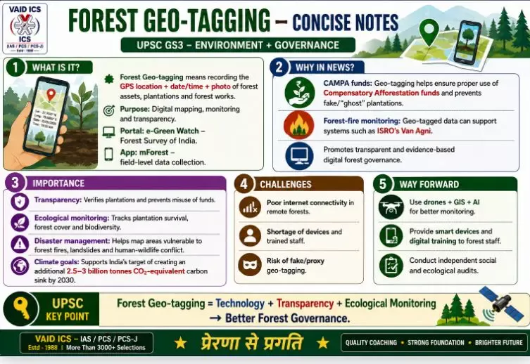
FOREST GEO-TAGGING
Why in News?
-
CAMPA Accountability: To ensure financial and physical transparency in the utilization of the ₹60,000+ crore Compensatory Afforestation Fund (CAMPA). Past audits by the CAG and strict observations by the Supreme Court flagged fund leakages and ‘ghost’ plantations, making 100% geo-tagging mandatory for all CAMPA-funded works.
-
Integration with Early Warning Systems: Recent scaling up has tightly linked geo-tagged forest assets with ISRO’s Van Agni fire alert system and state-level real-time governance grids to track forest degradation.
-
Digital Governance Push: The Ministry of Environment, Forest and Climate Change (MoEFCC) has emphasized nationwide expansion under “Digital India” to transition completely to transparent, evidence-based green governance.
about it?
-
Definition: Forest Geo-tagging is the process of assigning unique GPS coordinates along with date-time-stamped photographs to every forest asset, plantation, and management activity.
-
Objective: It maps forests, plantations, and infrastructure on a digital platform to enable real-time tracking, evaluation, and remote monitoring.
-
Nodal Portal: e-Green Watch (developed by the Forest Survey of India, Dehradun).
-
Nodal App: mForest (used by field staff to upload ground data).
Significance:
-
Governance & Transparency: Eliminates corruption and fake plantation claims by enabling public audits and independent verification of afforestation funds.
-
Ecological Monitoring: Cross-verification via satellite data and GIS mapping helps track the survival rate of saplings, biodiversity health, and spatial changes in forest cover over time.
-
Disaster Management: Aids rapid response during forest fires, landslides, and human-wildlife conflicts by dynamically mapping vulnerable zones.
-
Climate Commitments: Supports India’s Nationally Determined Contributions (NDC) target to create an additional carbon sink of 2.5 to 3 billion tonnes of $\text{CO}_2$ equivalent by 2030 through accountable afforestation.
Challenges:
-
Technical Constraints: Poor or non-existent internet connectivity in remote, dense forest areas delays real-time data uploading.
-
Implementation Bottlenecks: Shortage of geo-tagged-enabled devices and inadequate technical training for frontline forest guards.
-
Loop-holes: Incidents of proxy or fake geo-tagging using recycled old photographs, bypassing system checks.
Way Forward:
-
Tech Upgrade: Integrate field geo-tagging with drone surveillance and AI-based change detection models for automated discrepancy alerts.
-
Capacity Building: Equip all frontline workers with rugged, smart devices and continuous digital skill training.
-
Independent Audits: Mandate periodic third-party social and ecological audits of all geo-tagged forest assets.
Conclusion:
Forest Geo-tagging marks a definitive paradigm shift from paper-based accountability to evidence-based digital forest governance, ensuring optimal resource utilization and robust ecological protection.
वन जियो-टैगिंग (Forest Geo-tagging):
यूपीएससी जीएस3 – पर्यावरण + शासन (UPSC GS3 – Environment + Governance)
यह चर्चा में क्यों था:
CAMPA जवाबदेही: ₹60,000+ करोड़ के क्षतिपूरक वनीकरण कोष (CAMPA) के उपयोग में वित्तीय और भौतिक पारदर्शिता सुनिश्चित करना। सीएजी (CAG) के पिछले ऑडिट और सुप्रीम कोर्ट की कड़ी टिप्पणियों ने फंड के रिसाव और ‘भूतिया’ (Ghost) पौधारोपण को उजागर किया था, जिसके बाद सभी CAMPA-वित्त पोषित कार्यों के लिए 100% जियो-टैगिंग अनिवार्य कर दी गई।
प्रारंभिक चेतावनी प्रणालियों के साथ एकीकरण: हाल के विस्तार ने वनों की कटाई को ट्रैक करने के लिए जियो-टैग किए गए वन संपर्कों को इसरो (ISRO) की ‘वन अग्नि’ (Van Agni) फायर अलर्ट प्रणाली और राज्य-स्तरीय वास्तविक समय शासन ग्रिड से मजबूती से जोड़ दिया है।
डिजिटल गवर्नेंस पर जोर: पर्यावरण, वन और जलवायु परिवर्तन मंत्रालय (MoEFCC) ने पारदर्शी, साक्ष्य-आधारित हरित शासन में पूरी तरह से बदलाव के लिए “डिजिटल इंडिया” के तहत देशव्यापी विस्तार पर जोर दिया है।
यह क्या है:
परिभाषा: वन जियो-टैगिंग प्रत्येक वन संपत्ति, पौधारोपण और प्रबंधन गतिविधि को तिथि-समय मुद्रांकित (Date-time stamped) तस्वीरों के साथ अद्वितीय जीपीएस निर्देशांक (GPS coordinates) असाइन करने की प्रक्रिया है।
उद्देश्य: यह वास्तविक समय में ट्रैकिंग, मूल्यांकन और दूरस्थ निगरानी को सक्षम करने के लिए डिजिटल प्लेटफॉर्म पर जंगलों, वृक्षारोपण और बुनियादी ढांचे को मैप करता है।
नोडल पोर्टल: ई-ग्रीन वॉच (e-Green Watch) – वन सर्वेक्षण संस्थान, देहरादून द्वारा विकसित।
नोडल ऐप: mForest – मैदानी कर्मचारियों द्वारा ग्राउंड डेटा अपलोड करने के लिए उपयोग किया जाता है।
महत्व:
शासन और पारदर्शिता: यह वनीकरण निधि के सार्वजनिक ऑडिट और स्वतंत्र सत्यापन को सक्षम करके भ्रष्टाचार और फर्जी वृक्षारोपण के दावों को समाप्त करता है।
पारिस्थितिक निगरानी: उपग्रह डेटा और जीआईएस (GIS) मैपिंग के माध्यम से क्रॉस-सत्यापन से पौधों की उत्तरजीविता दर, जैव विविधता स्वास्थ्य और समय के साथ वन आवरण में स्थानिक परिवर्तनों को ट्रैक करने में मदद मिलती है।
आपदा प्रबंधन: यह कमजोर क्षेत्रों को गतिशील रूप से मैप करके वनों की आग, भूस्खलन और मानव-वन्यजीव संघर्ष के दौरान तेजी से प्रतिक्रिया में सहायता करता है।
जलवायु प्रतिबद्धताएं: यह जवाबदेह वनीकरण के माध्यम से 2030 तक 2.5 से 3 बिलियन टन $\text{CO}_2$ समतुल्य अतिरिक्त कार्बन सिंक बनाने के भारत के एनडीसी (NDC) लक्ष्य का समर्थन करता है।
चुनौतियाँ:
तकनीकी बाधाएं: दूरदराज के घने जंगलों में खराब या इंटरनेट कनेक्टिविटी न होने से वास्तविक समय में डेटा अपलोड करने में देरी होती है।
कार्यान्वयन संबंधी अड़चनें: जियो-टैगिंग सक्षम उपकरणों की कमी और फ्रंटलाइन वन रक्षकों के लिए अपर्याप्त तकनीकी प्रशिक्षण।
कमियां: पुरानी रीसायकल की गई तस्वीरों का उपयोग करके प्रॉक्सी या फर्जी जियो-टैगिंग की घटनाएं, जो सिस्टम जांच को बायपास करती हैं।
आगे की राह:
तकनीक अपग्रेड: स्वचालित विसंगति अलर्ट के लिए ड्रोन निगरानी और एआई-आधारित परिवर्तन पहचान मॉडल के साथ फील्ड जियो-टैगिंग को एकीकृत करना।
क्षमता निर्माण: सभी फ्रंटलाइन कामगारों को मजबूत, स्मार्ट उपकरणों और निरंतर डिजिटल कौशल प्रशिक्षण से लैस करना।
स्वतंत्र ऑडिट: सभी जियो-टैग की गई वन संपत्तियों के आवधिक तीसरे पक्ष के सामाजिक और पारिस्थितिक ऑडिट को अनिवार्य करना।
निष्कर्ष:
वन जियो-टैगिंग कागजी जवाबदेही से साक्ष्य-आधारित डिजिटल वन शासन की ओर एक निश्चित आदर्श बदलाव का प्रतीक है, जो इष्टतम संसाधन उपयोग और मजबूत पारिस्थितिक सुरक्षा सुनिश्चित करता है।

May 19, 2026
October 17, 2025
October 16, 2025
October 6, 2025

