October 6, 2025
What is Sir Creek Dispute?
Why in news ? The Sir Creek territorial dispute between India and Pakistan is in the news after escalating military tensions along the border in early October 2025. Defence Minister Rajnath Singh warned Pakistan of its deliberate stalling of the dispute over 78 years and highlighted Pakistan’s recent military expansion near Sir Creek, bringing the decades-old issue back into focus.
What is Sir Creek?
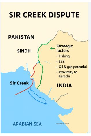
- Sir Creek (originally known as Ban Ganga) is a 96-km-long tidal estuary—a narrow, marshy waterway formed by the Indus River Delta—located in the uninhabited, flood-prone marshlands of the Rann of Kutch.
- It separates Gujarat in India from Sindh in Pakistan and flows westward into the Arabian Sea, serving as the westernmost point of the India-Pakistan land border. The area is sparsely populated, riddled with venomous wildlife like Russell’s vipers and scorpions, and becomes largely submerged during monsoons, making it challenging to patrol.
- The dispute originated from colonial-era ambiguities in the 1914 Bombay Government Resolution, which vaguely defined the boundary “from the mouth of Sir Creek to the top of Sir Creek.” After the 1947 Partition, Sindh went to Pakistan while Gujarat stayed with India. A 1965 war skirmish over the broader Rann of Kutch led to a 1968 UN tribunal award that resolved most land borders (favoring India 90-10), but left Sir Creek unresolved due to conflicting interpretations:
- India’s Position: The boundary runs through the mid-channel of the creek (applying the Thalweg Principle under international maritime law, which divides navigable waterways equitably). India supports this with 1925 maps and mid-channel boundary pillars installed in 1924, arguing the creek is navigable during high tides.
- Pakistan’s Position: The entire creek falls within its territory, with the boundary along the eastern bank (citing the 1914 resolution’s wording). Pakistan claims the creek is not navigable year-round, invalidating the Thalweg Principle.
This has stalled over a dozen rounds of bilateral talks since 1969, including joint surveys in 2007.
Strategic Importance for India:
- Sir Creek’s significance for India extends far beyond its modest size, encompassing military security, economic resources, and regional geopolitics. Control over the creek directly shapes the India-Pakistan maritime boundary in the Arabian Sea, affecting territorial waters, continental shelves, and Exclusive Economic Zones (EEZs)—200-nautical-mile zones where nations have sovereign rights to resources.
Key Strategic Dimensions of Sir Creek:
- Military & Security:
- Acts as a gateway to Karachi; potential “road to Karachi” for rapid advances.
- Vulnerable to infiltration, terrorism, and drone attacks (e.g., 2008 Mumbai attacks, May 2025 drone attempts).
- Protects Gujarat’s coastline and major ports (Kandla, Mundra).
- Shifting channels complicate border patrolling; resolution would improve surveillance.
- Economic Resources:
- Potential oil and gas reserves; crucial for energy security.
- Rich fishing grounds supporting local livelihoods; frequent accidental crossings cause detentions.
- Influences continental shelf and EEZ claims; India’s 2023 UN shelf submission depends on delimitation.
- Geopolitical & Ecological:
- Strategic tension from China-Pakistan projects near Rann.
- Ecological hotspot with mangroves and wildlife; affected by Pakistan’s LBOD discharge.
- Fisherman welfare: resolution could reduce detentions and boost confidence-building.
Gist of daily Article /The Hindu 17oct 2025
October 17, 2025
Daily Gist of the Hindu/Indian Express : 16 Oct 2025
October 16, 2025
Daily Gist of The Hindu/Indian Express: 6 Oct 2025
October 6, 2025
Daily Gist of Article /The Hindu /Indian Express: 24 Sep 2025
September 24, 2025