September 23, 2026
Dharali Flash Flood/Srikanta Glacier/धराली आकस्मिक बाढ़
Why in News?
-
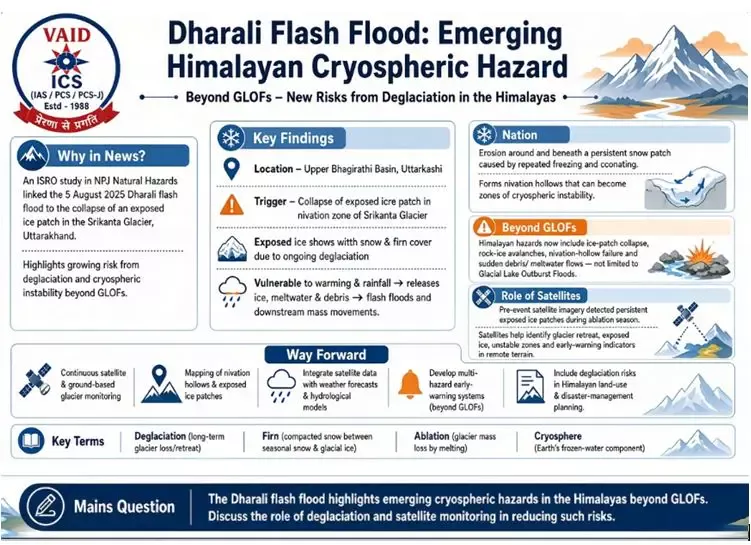
A study by ISRO scientists, published in NPJ Natural Hazards, examined the 5 August 2025 flash flood that devastated Dharali, Uttarakhand.
-
The study identified the collapse of an exposed ice patch in the Srikanta Glacier as the main trigger.
-
It highlights the emerging link between Himalayan deglaciation, warming temperatures and cryo-hydrological hazards.
Key Findings:
-
The event occurred in the upper Bhagirathi basin, Uttarkashi, along the Khir Gad stream, which originates from the Srikanta Glacier and flows through Dharali before joining the Bhagirathi.
-
Exposed ice patches were observed on steep slopes before the event.
-
Their exposure indicated thinning of seasonal snow and firn, consistent with ongoing deglaciation.
-
Exposed ice is more sensitive to temperature fluctuations and heavy rainfall, increasing the possibility of melting, fragmentation and collapse.
-
The released ice, meltwater and debris can generate sudden downstream flooding and mass movement.
What is Nivation?
-
Nivation is the erosion of ground beneath and around a persistent snow patch due mainly to repeated freezing and thawing.
-
It can create a nivation hollow, which gradually deepens as snow repeatedly accumulates at the same location.
-
Such hollows can become geomorphologically sensitive zones for ice and debris instability.
Why are Exposed Ice Patches Important?
-
Snow and firn provide an insulating cover over underlying ice.
-
Warming can reduce this protective layer, exposing glacial ice.
-
Exposed ice responds more rapidly to warming and rainfall.
-
It may therefore melt, fragment or collapse, releasing water and debris.
-
Thus, exposed ice patches can serve as early indicators of increasing cryospheric instability.
Beyond GLOFs:
-
Himalayan disaster monitoring often focuses on Glacial Lake Outburst Floods (GLOFs).
-
The Dharali event shows that hazards can also originate from smaller and less-recognised glacier instabilities.
-
These include:
-
Ice-patch collapse
-
Rock-ice avalanches
-
Nivation-hollow instability
-
Sudden meltwater and debris release
-
Role of Satellite Monitoring:
-
Pre-event satellite imagery helped identify persistent exposed ice patches during the glacier’s ablation period.
-
Earth-observation data can help:
-
Detect changing snow and firn cover.
-
Identify unstable ice patches and nivation hollows.
-
Monitor glacier retreat and deglaciation.
-
Reconstruct extreme events in remote terrain.
-
Develop early-warning indicators.
-
Significance:
-
Demonstrates the cascading impact of climate change on mountain hazards.
-
Expands the understanding of cryosphere-related disasters beyond GLOFs.
-
Highlights the importance of satellite-based monitoring in inaccessible Himalayan terrain.
-
Shows that small-scale glacier instabilities can produce large downstream impacts.
-
Provides inputs for disaster-risk reduction and climate adaptation in Himalayan settlements.
Key Challenges:
-
Rapid glacier retreat and deglaciation.
-
Limited ground-based monitoring in remote Himalayan areas.
-
Difficulty in detecting small ice instabilities.
-
Complex interaction between ice, snow, rainfall, slope and debris.
-
Growing exposure of downstream settlements and infrastructure to cryospheric hazards.
Way Forward:
-
Establish systematic satellite-based monitoring of vulnerable glaciers.
-
Develop inventories of nivation hollows and exposed ice patches.
-
Integrate satellite data with ground observations, weather forecasts and hydrological models.
-
Develop early-warning systems for multiple cryospheric hazards, not only GLOFs.
-
Strengthen community-based disaster preparedness in vulnerable valleys.
-
Incorporate deglaciation-related risks into Himalayan land-use and infrastructure planning.
Key Terms:
Deglaciation: Long-term reduction and retreat of glaciers.
Firn: Compacted, granular snow that survives at least one melting season and lies between seasonal snow and glacial ice.
Ablation: Loss of glacier mass through melting, sublimation and related processes.
Cryosphere: Frozen-water component of the Earth, including glaciers, snow, ice sheets, permafrost and sea ice.
Cryo-hydrological hazard: Hazard arising from interactions between frozen water, melting processes and the hydrological system.
Mains Question:
“The Dharali flash flood highlights the emergence of new cryospheric hazards in the Himalayas beyond Glacial Lake Outburst Floods. Discuss the role of deglaciation and satellite-based monitoring in Himalayan disaster-risk reduction.”
धराली आकस्मिक बाढ़: हिमनद बर्फ-पिंड का पतन एवं हिमालयी क्रायोस्फेरिक खतरे
चर्चा में क्यों?
-
ISRO के वैज्ञानिकों द्वारा किए गए एक अध्ययन, जो NPJ Natural Hazards में प्रकाशित हुआ है, ने 5 अगस्त 2025 को उत्तराखंड के धराली में आई आकस्मिक बाढ़ का विश्लेषण किया।
-
अध्ययन के अनुसार, बाढ़ का प्रमुख कारण श्रीकांता हिमनद के एक अनावृत बर्फ-पिंड का पतन था।
-
अध्ययन ने हिमालय में तापमान वृद्धि, हिमनद अपक्षय (Deglaciation) तथा क्रायोस्फेरिक-जलवैज्ञानिक आपदाओं के बीच संबंध को रेखांकित किया है।
प्रमुख निष्कर्ष:
-
घटना उत्तरकाशी जिले के ऊपरी भागीरथी नदी बेसिन में हुई।
-
खीर गाड़ जलधारा श्रीकांता हिमनद से निकलकर धराली से होकर भागीरथी नदी में मिलती है।
-
बाढ़ से पूर्व हिमनद की तीव्र ढालों पर अनावृत बर्फ-पिंड दिखाई दिए थे।
-
इनका अनावरण मौसमी हिम एवं फर्न (Firn) आवरण के पतले होने तथा निरंतर हिमनद अपक्षय का संकेत था।
-
अनावृत बर्फ तापमान में परिवर्तन एवं वर्षा के प्रति अधिक संवेदनशील होती है।
-
इसके पिघलने या टूटकर गिरने से बर्फ, हिम-पिघलित जल एवं अवसाद नीचे की ओर प्रवाहित होकर आकस्मिक बाढ़ एवं भूस्खलन जैसी प्रक्रियाओं को उत्पन्न कर सकते हैं।
निवेशन (Nivation) क्या है?
-
निवेशन वह भू-आकृतिक अपरदन प्रक्रिया है, जिसमें हिम या बर्फ के आवरण के नीचे एवं आसपास की भूमि का अपरदन मुख्यतः बार-बार जमने और पिघलने की प्रक्रिया से होता है।
-
इसके परिणामस्वरूप निवेशन गर्त (Nivation Hollow) का निर्माण हो सकता है।
-
ऐसे गर्तों में लंबे समय तक हिम के संचयन से उनका आकार एवं गहराई बढ़ सकती है।
-
ये क्षेत्र हिमनदीय अस्थिरता के संवेदनशील क्षेत्र बन सकते हैं।
अनावृत बर्फ-पिंड क्यों महत्त्वपूर्ण हैं?
-
हिम एवं फर्न आवरण हिमनद की अंतर्निहित बर्फ को ऊष्मीय सुरक्षा प्रदान करता है।
-
तापमान वृद्धि से यह आवरण पतला होने पर बर्फ अनावृत हो जाती है।
-
अनावृत बर्फ तापमान वृद्धि एवं वर्षा के प्रति अधिक तीव्र प्रतिक्रिया करती है।
-
इससे बर्फ के पिघलने, विखंडन अथवा पतन की संभावना बढ़ती है।
-
अतः अनावृत बर्फ-पिंड हिमनद अस्थिरता एवं संभावित आपदा का प्रारंभिक संकेतक बन सकते हैं।
GLOF से आगे बढ़ते हिमालयी खतरे:
-
हिमालय में क्रायोस्फेरिक आपदाओं के संदर्भ में सामान्यतः हिमनदीय झील के अचानक फटने से आने वाली बाढ़ (GLOF) पर अधिक ध्यान दिया जाता है।
-
धराली की घटना दर्शाती है कि छोटे एवं अपेक्षाकृत कम पहचाने गए हिमनदीय अस्थिरता क्षेत्र भी गंभीर आपदा उत्पन्न कर सकते हैं।
-
इनमें शामिल हैं:
-
बर्फ-पिंड का पतन
-
शैल-बर्फ हिमस्खलन
-
निवेशन गर्तों की अस्थिरता
-
अचानक हिम-पिघलित जल एवं अवसाद का प्रवाह
-
उपग्रह निगरानी की भूमिका:
-
घटना से पूर्व प्राप्त उपग्रह चित्रों में अपक्षय काल के दौरान अनावृत बर्फ-पिंडों की उपस्थिति दिखाई दी।
-
पृथ्वी-अवलोकन तकनीक के माध्यम से:
-
हिम एवं फर्न आवरण में परिवर्तन की निगरानी।
-
अस्थिर बर्फ-पिंडों एवं निवेशन गर्तों की पहचान।
-
हिमनद अपक्षय एवं पीछे हटने की निगरानी।
-
दूरस्थ पर्वतीय क्षेत्रों में आपदाओं का पुनर्निर्माण।
-
प्रारंभिक चेतावनी संकेतकों का विकास किया जा सकता है।
-
भौगोलिक महत्त्व:
-
यह घटना जलवायु परिवर्तन और पर्वतीय भू-आकृतिक प्रक्रियाओं के बीच बढ़ते संबंध को दर्शाती है।
-
हिमालय में हिममंडलीय अस्थिरता नए प्रकार के आपदा जोखिम उत्पन्न कर रही है।
-
छोटे हिमनदीय परिवर्तनों का प्रभाव नीचे स्थित नदी घाटियों एवं बस्तियों तक पहुँच सकता है।
-
इससे हिमालयी क्षेत्रों में आपदा जोखिम न्यूनीकरण एवं जलवायु अनुकूलन की आवश्यकता बढ़ती है।
प्रमुख चुनौतियाँ:
-
तीव्र हिमनद अपक्षय एवं हिमनदों का पीछे हटना।
-
दुर्गम हिमालयी क्षेत्रों में सीमित स्थलीय निगरानी।
-
छोटे एवं छिपे हुए हिमनदीय अस्थिरता क्षेत्रों की पहचान में कठिनाई।
-
बर्फ, हिम, वर्षा, ढाल एवं अवसाद के बीच जटिल अंतःक्रिया।
-
हिमनदों के नीचे स्थित बस्तियों एवं अवसंरचना का बढ़ता आपदा जोखिम।
आगे की राह:
-
संवेदनशील हिमनदों की निरंतर उपग्रह-आधारित निगरानी की जाए।
-
निवेशन गर्तों एवं अनावृत बर्फ-पिंडों का व्यवस्थित मानचित्रण किया जाए।
-
उपग्रह आँकड़ों को स्थलीय निगरानी, मौसम पूर्वानुमान एवं जलवैज्ञानिक मॉडल से जोड़ा जाए।
-
प्रारंभिक चेतावनी प्रणाली को केवल GLOF तक सीमित न रखकर सभी प्रमुख हिममंडलीय खतरों तक विस्तारित किया जाए।
-
संवेदनशील नदी घाटियों में स्थानीय समुदाय आधारित आपदा तैयारी को मजबूत किया जाए।
-
हिमनद अपक्षय से उत्पन्न जोखिमों को हिमालयी क्षेत्र की भूमि-उपयोग एवं अवसंरचना योजना में शामिल किया जाए।
प्रमुख भौगोलिक शब्द:
हिमनद अपक्षय (Deglaciation): दीर्घकाल में हिमनदों के आकार एवं द्रव्यमान में कमी तथा उनका पीछे हटना।
फर्न (Firn): पुराना, सघन एवं दानेदार हिम, जो मौसमी हिम और पूर्णतः विकसित हिमनदीय बर्फ के बीच की अवस्था में होता है।
अपक्षय (Ablation): हिमनद के द्रव्यमान में कमी की प्रक्रिया, जिसमें मुख्यतः पिघलना एवं उर्ध्वपातन शामिल हैं।
हिममंडल (Cryosphere): पृथ्वी पर जमे हुए जल का क्षेत्र, जिसमें हिमनद, हिम, हिमचादर, समुद्री बर्फ एवं स्थायी तुषारभूमि आदि शामिल हैं।
क्रायो-जलवैज्ञानिक खतरा: हिम, बर्फ, हिमनदों के पिघलने तथा जलवैज्ञानिक प्रक्रियाओं की अंतःक्रिया से उत्पन्न आपदा जोखिम।
Mains Question:
“धराली की आकस्मिक बाढ़ हिमालय में हिमनदीय झील के अचानक फटने से उत्पन्न बाढ़ (GLOF) से परे उभरते क्रायोस्फेरिक खतरों को दर्शाती है। हिमनद अपक्षय तथा उपग्रह-आधारित निगरानी की भूमिका के संदर्भ में हिमालयी आपदा जोखिम न्यूनीकरण के उपायों की चर्चा कीजिए।”

May 19, 2026
October 17, 2025
October 16, 2025
October 6, 2025

