September 16, 2026
Himalayan Glaciers: Approaching a Tipping Point/”पीक वाटर” क्या है?
Why in News?
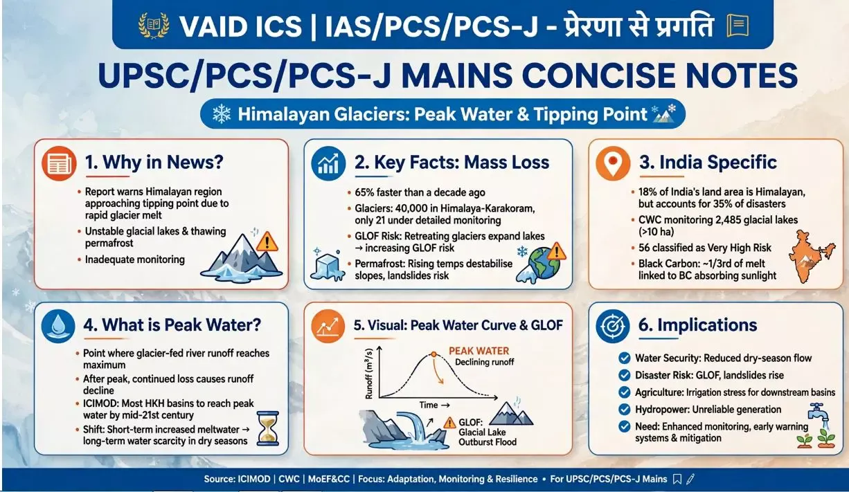
A new research report has warned that the Himalayan region is approaching a dangerous threshold due to accelerating glacier melt, growing instability of glacial lakes, thawing permafrost and inadequate monitoring.
The findings highlight increasing risks of Glacial Lake Outburst Floods (GLOFs), landslides, flash floods and water insecurity across the Hindu Kush Himalayan region.
Key Findings:
-
Himalayan glaciers are losing mass 65% faster than a decade ago.
-
Of an estimated 40,000 glaciers across the Himalaya–Karakoram region, only about 21 are being monitored in detail on a sustained basis.
-
Glacier retreat is leading to the formation and expansion of glacial lakes, many of which may be held back by unstable rock and ice deposits.
-
Rising temperatures are also destabilising permafrost and high-mountain slopes.
-
These changes can trigger cascading hazards, where one event leads to multiple connected disasters.
Why is Glacier Melt Dangerous?
1. Glacial Lake Outburst Floods (GLOFs):
As glaciers retreat, meltwater can accumulate in lakes behind unstable natural dams made of ice, rock and debris.
Failure of these natural dams can suddenly release huge volumes of water, causing flash floods downstream.
2. Permafrost Destabilisation:
-
Permafrost is ground that remains frozen for long periods.
-
Rising temperatures can cause it to thaw.
-
This can weaken mountain slopes and increase the risk of landslides and rockfalls.
3. Cascading Hazards:
Glacier retreat → expanding glacial lakes → unstable slopes → landslides/GLOFs → downstream flooding → damage to roads, bridges, settlements and hydropower infrastructure.
Evidence from India:
The Indian Himalayan region provides several examples of these risks:
-
2023 Sikkim GLOF: A glacial lake outburst triggered a major flash flood, causing extensive damage to roads, bridges and hydropower projects.
-
2021 Uttarakhand disaster: A massive flood in the Rishiganga and Dhauliganga valleys caused more than 200 deaths and severe infrastructure damage.
-
According to the report, the Indian Himalayan region accounts for about 18% of India’s land area but around 35% of disasters.
Glacial Lakes in India:
The Central Water Commission (CWC) is monitoring 2,485 glacial lakes larger than 10 hectares across India’s Himalayan river basins.
Following a scientific assessment of 189 high-risk glacial lakes, 56 lakes were classified as “very high risk” by the government.
Why is Himalayan Water Important?
The Himalayas are a major natural water system for South Asia, feeding rivers that support hundreds of millions of people.
Himalayan water supports:
-
Agriculture – wheat, rice and other crops
-
Tea cultivation
-
Hydropower generation
-
Drinking water
-
Tourism and pilgrimage
-
Rural livelihoods and ecosystems
The report estimates that Himalayan water supports activities equivalent to around 20% of India’s GDP, while Himalayan mountain states capture only about 5% of this economic value.
What is “Peak Water”?
Peak water refers to the point at which glacier runoff reaches its maximum, after which water availability from glacier melt begins to decline as glaciers lose mass.
According to ICIMOD, most Hindu Kush Himalayan river basins are expected to reach peak water around the middle of the century.
Significance:
Initially, accelerated melting may increase water availability, but continued glacier loss can eventually lead to declining dry-season water flows.
Black Carbon: An Important Concern
The report estimates that approximately one-third of Himalayan glacier melt is linked to black carbon.
Black carbon is soot produced by incomplete combustion.
Major sources include:
-
Brick kilns
-
Biomass burning
-
Diesel combustion
-
Other combustion-related activities
When black carbon settles on snow and ice, it absorbs sunlight, increasing the rate of melting.
Importance: Unlike global greenhouse-gas emissions, reducing black-carbon emissions is a more direct and regionally actionable measure for India and neighbouring countries.
Tourism and Environmental Pressure:
The Indian Himalayan region receives approximately 400 million tourist visits annually.
The report argues for moving from a model focused primarily on increasing tourist numbers towards sustainable, high-value tourism, where greater economic benefits are retained and reinvested locally.
Major Challenges:
-
Accelerating glacier loss
-
Expansion of unstable glacial lakes
-
Thawing permafrost
-
Increasing landslide and GLOF risks
-
Insufficient glacier monitoring
-
Vulnerability of downstream infrastructure
-
Unsustainable tourism
-
Limited cross-border coordination
Way Forward:
1. Strengthen Glacier Monitoring:
Expand long-term monitoring using satellites, remote sensing, ground observations and automated systems.
2. Improve Early-Warning Systems:
Develop integrated systems for GLOFs, floods, landslides and other mountain hazards.
3. Reduce Black Carbon:
Target emissions from brick kilns, transport and biomass burning.
4. Strengthen Disaster Preparedness:
Governments should establish pre-agreed evacuation and emergency-response protocols.
5. Climate-Resilient Infrastructure:
Roads, bridges, hydropower projects and settlements should incorporate mountain-specific climate and disaster risks.
6. Sustainable Tourism:
Shift from mass tourism towards environmentally sustainable and locally beneficial tourism.
7. Regional Cooperation:
Himalayan hazards cross national boundaries; therefore, countries need shared monitoring, risk information, early-warning systems and joint resilience investments.
Significance for India:
The Himalayan crisis is not merely an environmental issue. It has implications for:
-
Water security
-
Food security
-
Energy security
-
Disaster management
-
Mountain livelihoods
-
Infrastructure
-
Tourism
-
Inter-State and transboundary cooperation
हिमालयी हिमनद: एक संभावित संकट-बिंदु की ओर
चर्चा में क्यों?
एक नए शोध अध्ययन के अनुसार, हिमालयी क्षेत्र एक गंभीर संकट-बिंदु (Tipping Point) की ओर बढ़ रहा है। हिमनदों के तेजी से पिघलने, हिमनदीय झीलों की बढ़ती अस्थिरता, स्थायी रूप से जमी भूमि (Permafrost) के पिघलने तथा निगरानी की कमी के कारण आपदाओं का जोखिम बढ़ रहा है।
यह स्थिति हिमनदीय झील के फटने से आने वाली बाढ़ (GLOF), भूस्खलन, आकस्मिक बाढ़ और जल असुरक्षा जैसी समस्याओं को बढ़ा सकती है।
प्रमुख निष्कर्ष:
-
हिमालयी हिमनदों का द्रव्यमान ह्रास एक दशक पहले की तुलना में 65% अधिक तेजी से हो रहा है।
-
हिमालय-काराकोरम क्षेत्र में लगभग 40,000 हिमनद होने का अनुमान है, लेकिन केवल लगभग 21 हिमनदों की विस्तृत और निरंतर निगरानी की जा रही है।
-
हिमनदों के पीछे हटने से हिमनदीय झीलों का विस्तार हो रहा है।
-
इन झीलों को अक्सर चट्टानों, बर्फ और मलबे से बने अस्थिर प्राकृतिक बांध रोकते हैं।
-
बढ़ते तापमान के कारण परमाफ्रॉस्ट और ऊँचे पर्वतीय ढलानों की स्थिरता भी प्रभावित हो रही है।
-
इसके परिणामस्वरूप क्रमिक एवं परस्पर जुड़े हुए खतरे (Cascading Hazards) उत्पन्न हो सकते हैं।
हिमनदों का पिघलना क्यों चिंताजनक है?
1. हिमनदीय झील विस्फोट बाढ़ (GLOF):
हिमनदों के पिघलने से पिघला हुआ जल झीलों में जमा होता जाता है। यदि इन झीलों के प्राकृतिक बांध टूट जाते हैं, तो बड़ी मात्रा में जल अचानक नीचे की ओर बह सकता है और विनाशकारी बाढ़ ला सकता है।
2. परमाफ्रॉस्ट का पिघलना:
-
परमाफ्रॉस्ट ऐसी भूमि है जो लंबे समय तक जमी रहती है।
-
तापमान बढ़ने से इसके पिघलने की प्रक्रिया तेज होती है।
-
इससे पर्वतीय ढलान कमजोर होकर भूस्खलन और चट्टानों के खिसकने का जोखिम बढ़ा सकते हैं।
3. क्रमिक आपदाएँ:
हिमनदों का पीछे हटना → हिमनदीय झीलों का विस्तार → पर्वतीय ढलानों की अस्थिरता → भूस्खलन/GLOF → बाढ़ → बुनियादी ढाँचे को नुकसान
भारत में इसके प्रमाण:
भारत के हिमालयी क्षेत्र में इस बढ़ते जोखिम के कई उदाहरण देखे गए हैं।
-
2023 सिक्किम GLOF: हिमनदीय झील के फटने से अचानक बाढ़ आई तथा सड़क, पुल और जलविद्युत परियोजनाओं को व्यापक क्षति हुई।
-
2021 उत्तराखंड आपदा: ऋषिगंगा और धौलीगंगा घाटियों में आई भीषण बाढ़ में 200 से अधिक लोगों की मृत्यु हुई और बुनियादी ढाँचे को भारी नुकसान पहुँचा।
-
रिपोर्ट के अनुसार, भारत के कुल भू-भाग का लगभग 18% हिमालयी क्षेत्र में है, लेकिन देश की लगभग 35% आपदाएँ इसी क्षेत्र से संबंधित हैं।
भारत में हिमनदीय झीलों की निगरानी:
केंद्रीय जल आयोग (CWC) भारत के हिमालयी नदी बेसिनों में 10 हेक्टेयर से बड़ी 2,485 हिमनदीय झीलों की निगरानी कर रहा है।
2025 के वैज्ञानिक आकलन के बाद 189 उच्च-जोखिम वाली हिमनदीय झीलों का मूल्यांकन किया गया, जिनमें 56 झीलों को “अति उच्च जोखिम” (Very High Risk) श्रेणी में रखा गया।
हिमालयी जल क्यों महत्वपूर्ण है?
हिमालय दक्षिण एशिया की एक महत्वपूर्ण प्राकृतिक जल प्रणाली है। इससे निकलने वाली नदियाँ करोड़ों लोगों की आवश्यकताओं को पूरा करती हैं।
हिमालयी जल निम्नलिखित क्षेत्रों के लिए महत्वपूर्ण है:
-
कृषि – गेहूँ, चावल आदि
-
चाय उत्पादन
-
जलविद्युत
-
पेयजल
-
पर्यटन एवं तीर्थाटन
-
स्थानीय आजीविका
-
पारिस्थितिकी तंत्र
रिपोर्ट के अनुसार, हिमालयी जल से जुड़ी आर्थिक गतिविधियाँ भारत के सकल घरेलू उत्पाद (GDP) के लगभग 20% के बराबर हैं, जबकि पर्वतीय राज्य इस आर्थिक मूल्य का केवल लगभग 5% ही प्राप्त करते हैं।
“पीक वाटर” क्या है?
पीक वाटर (Peak Water) वह स्थिति है जब हिमनदों से होने वाला जल प्रवाह अपने अधिकतम स्तर पर पहुँच जाता है, जिसके बाद हिमनदों के लगातार घटने के कारण जल प्रवाह में कमी आने लगती है।
ICIMOD के अनुसार, अधिकांश हिंदूकुश-हिमालयी (HKH) नदी बेसिनों में मध्य शताब्दी के आसपास पीक वाटर आने की संभावना है।
महत्व: प्रारंभिक चरण में तेजी से हिमनद पिघलने से जल उपलब्धता बढ़ सकती है, लेकिन लंबे समय में हिमनदों के लगातार सिकुड़ने से विशेषकर शुष्क मौसम में नदी प्रवाह कम हो सकता है।
ब्लैक कार्बन की भूमिका:
रिपोर्ट के अनुसार, हिमालयी हिमनदों के पिघलने का लगभग एक-तिहाई हिस्सा ब्लैक कार्बन से संबंधित हो सकता है।
ब्लैक कार्बन अपूर्ण दहन से उत्पन्न होने वाला कालिखयुक्त पदार्थ है।
इसके प्रमुख स्रोत हैं:
-
ईंट भट्टे
-
जैव-ईंधन का दहन
-
डीजल से होने वाला प्रदूषण
-
अन्य दहन प्रक्रियाएँ
जब ब्लैक कार्बन बर्फ और हिम पर जमता है, तो यह सूर्य के विकिरण को अधिक अवशोषित करता है, जिससे हिम पिघलने की गति बढ़ जाती है।
पर्यटन का बढ़ता दबाव:
भारतीय हिमालयी क्षेत्र में प्रतिवर्ष लगभग 40 करोड़ पर्यटक यात्राएँ होती हैं।
शोधकर्ताओं के अनुसार, पर्यटन नीति को केवल पर्यटकों की संख्या बढ़ाने के बजाय ऐसे मॉडल की ओर ले जाना चाहिए जिसमें स्थानीय समुदायों को अधिक आर्थिक लाभ मिले और उस आय का एक हिस्सा स्थानीय पर्यावरण एवं बुनियादी ढाँचे में पुनर्निवेशित किया जाए।
प्रमुख चुनौतियाँ:
-
हिमनदों का तेजी से सिकुड़ना
-
हिमनदीय झीलों का विस्तार
-
परमाफ्रॉस्ट का पिघलना
-
भूस्खलन और GLOF का बढ़ता खतरा
-
हिमनदों की अपर्याप्त निगरानी
-
बुनियादी ढाँचे की संवेदनशीलता
-
अनियंत्रित/असतत पर्यटन
-
सीमा-पार समन्वय की कमी
आगे की राह:
1. हिमनद निगरानी को मजबूत करना:
उपग्रह, रिमोट सेंसिंग, जमीनी अवलोकन और स्वचालित प्रणालियों के माध्यम से दीर्घकालिक निगरानी बढ़ाई जानी चाहिए।
2. पूर्व चेतावनी प्रणाली:
GLOF, बाढ़ और भूस्खलन के लिए प्रभावी Early Warning Systems विकसित किए जाने चाहिए।
3. ब्लैक कार्बन में कमी:
ईंट भट्टों, परिवहन और जैव-ईंधन से होने वाले उत्सर्जन को कम करना आवश्यक है।
4. आपदा तैयारी:
सरकारों को जोखिम की स्थिति में पूर्व निर्धारित निकासी और आपातकालीन प्रतिक्रिया व्यवस्था विकसित करनी चाहिए।
5. जलवायु-लचीला बुनियादी ढाँचा:
सड़कों, पुलों, जलविद्युत परियोजनाओं और बस्तियों में पर्वतीय क्षेत्रों से जुड़े जलवायु एवं आपदा जोखिमों को ध्यान में रखना चाहिए।
6. सतत पर्यटन:
अत्यधिक पर्यटक संख्या के बजाय पर्यावरणीय रूप से टिकाऊ और स्थानीय समुदायों को लाभ पहुँचाने वाले पर्यटन को बढ़ावा देना चाहिए।
7. क्षेत्रीय सहयोग:
हिमालयी आपदाएँ राष्ट्रीय सीमाओं का पालन नहीं करतीं। इसलिए देशों के बीच साझा निगरानी, जोखिम संबंधी सूचना, पूर्व चेतावनी प्रणाली और आपदा-रोधी निवेश को मजबूत करना आवश्यक है।
भारत के लिए महत्व:
हिमालयी संकट केवल पर्यावरणीय समस्या नहीं है, बल्कि इसका सीधा संबंध है:
-
जल सुरक्षा
-
खाद्य सुरक्षा
-
ऊर्जा सुरक्षा
-
आपदा प्रबंधन
-
पर्वतीय आजीविका
-
बुनियादी ढाँचा
-
पर्यटन
-
अंतर्राज्यीय एवं सीमा-पार सहयोग

May 19, 2026
October 17, 2025
October 16, 2025
October 6, 2025

