May 5, 2026
Global Environmental Alert: The Sinking of Mexico City:
Why in News?
- The 2026 NISAR Data: Newly released imagery from the NASA-ISRO Synthetic Aperture Radar (NISAR) satellite (launched in 2025) has provided the most precise maps to date of Mexico City’s descent.
- Critical Findings: Data from October 2025 to January 2026 confirms that parts of the city are sinking by more than 2 cm every month (approx. 25 cm per year), threatening vital infrastructure.
Reasons for Sinking (Land Subsidence):
The crisis is a result of a centuries-old “man vs. nature” conflict:
- Historical Geography: The city is built on the soft, clay-rich bed of the former Lake Texcoco.
- Aquifer Over-extraction: To sustain 20 million people, the city pumps vast amounts of groundwater. As the water is removed, the clay soil collapses and compacts (the “Sponge” effect).
- Urban Weight: The sheer mass of skyscrapers and heavy urban development further accelerates the compaction of the soft lakebed.
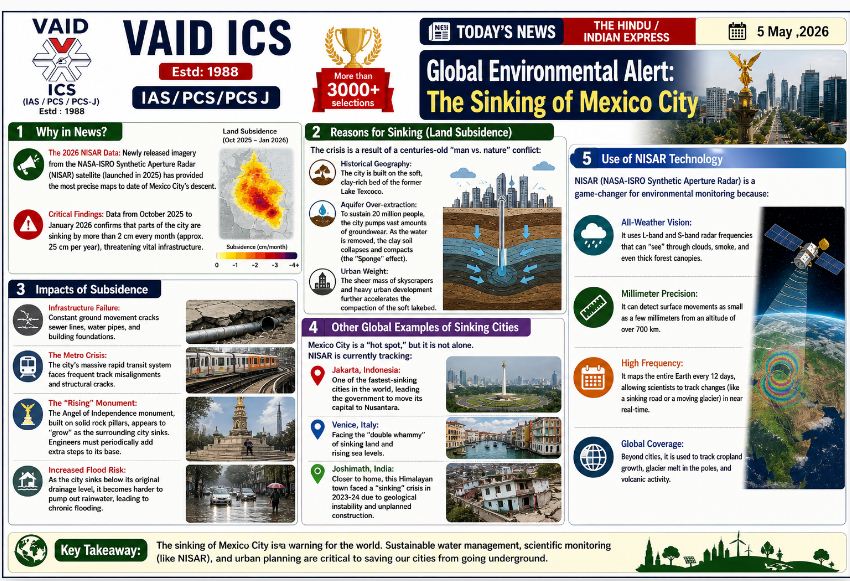
Impacts of Subsidence:
- Infrastructure Failure: Constant ground movement cracks sewer lines, water pipes, and building foundations.
- The Metro Crisis: The city’s massive rapid transit system faces frequent track misalignments and structural cracks.
- The “Rising” Monument: The Angel of Independence monument, built on solid rock pillars, appears to “grow” as the surrounding city sinks. Engineers must periodically add extra steps to its base.
- Increased Flood Risk: As the city sinks below its original drainage level, it becomes harder to pump out rainwater, leading to chronic flooding.
Other Global Examples of Sinking Cities:
Mexico City is a “hot spot,” but it is not alone. NISAR is currently tracking:
- Jakarta, Indonesia: One of the fastest-sinking cities in the world, leading the government to move its capital to Nusantara.
- Venice, Italy: Facing the “double whammy” of sinking land and rising sea levels.
- Joshimath, India: Closer to home, this Himalayan town faced a “sinking” crisis in 2023-24 due to geological instability and unplanned construction.
Use of NISAR Technology:
NISAR (NASA-ISRO Synthetic Aperture Radar) is a game-changer for environmental monitoring because:
- All-Weather Vision: It uses L-band and S-band radar frequencies that can “see” through clouds, smoke, and even thick forest canopies.
- Millimeter Precision: It can detect surface movements as small as a few millimeters from an altitude of over 700 km.
- High Frequency: It maps the entire Earth every 12 days, allowing scientists to track changes (like a sinking road or a moving glacier) in near real-time.
- Global Coverage: Beyond cities, it is used to track cropland growth, glacier melt in the poles, and volcanic activity.
Gist of daily Article /The Hindu 17oct 2025
October 17, 2025
Daily Gist of the Hindu/Indian Express : 16 Oct 2025
October 16, 2025
Daily Gist of The Hindu/Indian Express: 6 Oct 2025
October 6, 2025
Daily Gist of Article /The Hindu /Indian Express: 24 Sep 2025
September 24, 2025